Wintry weather to wane by weekend
Published 12:33 pm Tuesday, January 16, 2018
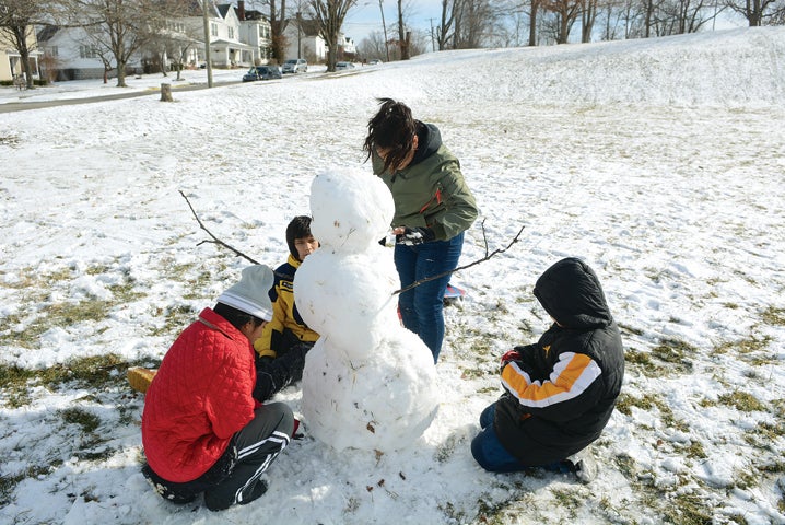
- Josefina Rodriguez, Mateo Rodriguez, Ruth Torres and Moses Torres work together to build a snowman during their day off of school Monday. (Photo by Seth Littrell)
While Clark County avoided most of the expected big hit of a winter storm that swept through Kentucky and Indiana over the weekend, more snowfall is anticipated through early morning today. But, a warm up is expected by the end of the week.
The weekend storm did bring a little bit of everything, with rain, freezing rain, sleet, snow and gusty winds. Weather officials called for two to six inches throughout Central Kentucky over the weekend, but reports indicate most of the area was left with less than two inches of accumulation come Saturday morning. Ice ranged up to a quarter inch in some areas, and travel conditions were mostly impacted through Friday night.
“We didn’t really have much of anything compared to what they expected for us this weekend,” Clark County Emergency Management Director Gary Epperson said. “We didn’t have anything major. Beyond cold temperatures and a few slick roads, we were lucky.”
NWS anticipated an additional one to two inches to accumulate across the region Monday night, with five to six hours of light snowfall lasting until about 10 a.m. today.
“After the snow clears out, temperatures will plunge into the single digits,” NWS warns. “Northwest winds gusting 10-15 mph will send wind chills to around 10 below zero in some areas.”
With temperatures that low, Epperson said the concern will be protecting against the elements.
Epperson said the Beacon of Hope and other agencies have been working throughout the winter to make sure warm places are available for those without shelter or heat.
“The shelters have stayed pretty maxed out,” he said. “If someone does have a need, they just have to call the police department and they will give instructions about how to get accommodations. Whether we can get them into the shelter, if we have to open up a church for people or we need to put a family up somewhere for the night, we will make sure there is a place if it is needed.”
Epperson said there are not traditional “warming centers” open at the moment, but decisions will be made based on need.
He warns that with cold temperatures, a secondary heat source should be available at at all times.
“Don’t be totally dependent on electricity,” he said. “If there is a power outage, you don’t want to be stuck without heat. It doesn’t hurt to have a kerosene or propane heat source available.”
Epperson also encourages having “back up kits” for emergency situations at home and in vehicles.
“Have extra food, water and blankets at home,” he said. “Keep extra warm clothes, boots, blankets and some sort of snacks like energy bars in your vehicle.”
With extremely low temperatures, Epperson also asks that people check in on elderly or disabled neighbors and relatives and keep an eye out for people without shelter.
“Just be good neighbors and keep an eye for people,” he said.
This bluster of frigid temperatures will last through Wednesday, but Clark and surrounding counties can expect some relief from the extreme winter weather by Thursday. The warm up will come towards the end of the week with highs near 42 Friday and 51 Saturday. Sunday could bring rain with a high near 59.
However, Epperson warns winter is not over.
“Just take basic precautions throughout the season,” he said. “Be prepared for the weather by having things in place if we should experience extreme weather like heavy snow or ice that might cause power outages or hamper travel.”
About Whitney Leggett
Whitney Leggett is managing editor of The Winchester Sun and Winchester Living magazine. To contact her, email whitney.leggett@winchestersun.com or call 859-759-0049.
 More by Whitney