Roadside history: Historical markers help tell stories of county’s past
Published 8:41 am Saturday, January 20, 2018

Towering signs along Kentucky roadways tell the stories of the men and women, the places and events that shaped the Commonwealth.
The Kentucky Historical Society estimates there are at least 2,400 official historical markers throughout the state with brief but significant information about Kentucky’s past. Twenty-six of those markers call Clark County home.
From one end of the county to the other, and covering topics like famed Clark County artists, musicians and soldiers, to Civil War history and the accounts of the county’s first settlers, these markers provide insight into what transpired in particular areas.
In Clark County, these markers tell of Homer Ledford’s career as a bluegrass musician and instrument maker, of the rescue of Daniel Boone’s and Richard Callaway’s daughters from Native Americans along the Kentucky River, of the oldest continuously attended church in the state, of Civil War soldiers, Clark County’s roots in the hemp industry, of Kentucky’s 12th governor, who called Clark County home and more.
Beyond the role of preserving local history, these markers draw tourists and researchers to the area and the pique the interest of motorists traveling all areas of the county — from heavily-trafficked main roads to winding back roads.
Making markers
Although KHS recognizes thousands throughout the state, according to local historian Harry Enoch, the process of establishing a marker is not always a simple task.
Enoch played a key role in gaining approval for the county’s most recent markers commemorating the Boone-Callaway girls kidnapping and the Bush family’s contributions to the area. He said another marker is planned for installation in April detailing some of the history in the Schollsville area.
For Enoch, the challenge is not necessarily developing the plan or obtaining the necessary information, but rather securing funding for the markers, which cost $2,500 to $3,000.
“You come up with a theme that you want to recognize and then you need to get others in the community to agree this is worth commemorating and support the project,” he said. “I think Daniel Boone has always been a hit for me because he had many historic moments in Clark County that hadn’t been recognized. So, subject matter is first. Second, you need money.”
Enoch was able to secure a grant from The Greater Clark Foundation to fund his first marker. He did work on the Sphar Building project for Winchester-Clark County Tourism in exchange for funding for the Boone-Bush marker placed earlier this month.
Enoch said the application process can be lengthy, and KHS requires any statements made on the markers be verifiable through reliable primary sources.
“You have to come up with proof of each word of your statement,” he said. “You have to send KHS evidence that goes back to the original record. It can’t be a newspaper article or history book. It has to be documented from fact.”
KHS accepts applications for markers twice a year, with deadlines in March and September annually. Approximately 30 new markers are approved each year on various topics and in various communities throughout the state. Some communities boast as many as 120 or more markers, down to around five or six in other places.
According to KHS, “The Historical Marker Program is one of KHS’ most visible projects. Each marker represents a local story, engaged Kentuckians and a bridge between the past and the future. Each one started with a desire to preserve local history”
“The best thing about the marker program is that it is community driven. Instead of the Kentucky Historical Society determining what is important, local communities decide what matters to them and then work with KHS to commemorate it,” Amanda Higgins, community engagement administrator for KHS, said.
For Enoch, preserving history and sharing factual information about the county’s past is of utmost importance.
“I do think preserving our history is important,” he said. “We can’t preserve all the places and the buildings that we would like, but we can at least preserve the memories. We can place these markers and educate the public. I try to educate through my research, but by people stopping to read these markers that will increase the knowledge of local history.”
Economic impact
As Enoch notes, there is significant potential economic impact to establishing historical markers in the community.
“We may be able to get enough markers in our county that we can offer tours,” Enoch said.
For Winchester-Clark County Tourism Director Nancy Turner, that is exactly the plan. She would like to see various tours available utilizing local markers. Particularly, Turner said Clark County is often left out of history pertaining to Daniel Boone and Fort Boonesborough, and she would like to see that change.
“Several years ago, with the Buffalo Trace development to connect Boone’s path from Cumberland to Fort Boonesborough, Clark County was originally included in that discussion,” she said. “But, the trace ended at Fort Boonesborough. My thought process is to take folks from the fort to Clark County and end at Pilot’s Knob, where Boone first overlooked the Bluegrass. We have many connections we could use to teach about Boone beyond Boonesborough. That’s slowly coming to fruition.”
Turner has also been working closely with Clark County CGIS Coordinator Stephen Berry to create a map, like the one on pages A1 and A2, showing the locations of Clark County’s markers.
So far, Berry has made significant progress mapping the markers — along with other markers in the community that are not KHS-affiliated. Through a website Berry has been working on, residents and other interested people will be able to take a virtual tour of Clark County’s markers.
“KHS has an app that lists all the markers,” Turner said. “You can do a county search and it will tell you where the closest markers are and will give you some history. Stephen has worked with us to take that a step further locally, where you can tour the markers using his story map from the comfort of your home.”
For Turner, having markers can draw others to the area who might stay in Clark County, spending money and boosting the economy.
“Heritage and cultural tourism is one of the biggest tourism movements right now,” she said. “These folks tend to stay in communities longer and spend more money. From a genealogy standpoint, we are blessed to have all our records in the county. Our courthouse never burned or flooded, so folks have the ability to stay long-term and do that research. They can set up base in Winchester, and travel to area counties, but return here where they will spend money on lodging and fuel and food.”
And while boosting local tourism is Turner’s job, she also sees value in sharing the county’s history.
“In some instances, we are commemorating things that are still there, but more often than not, we are commemorating people or places that are no longer with us,” she said. “This gives us a more in-depth view of history and we can look at it more geographically. And with the KHS markers, there is more credibility, because the information has been thoroughly vetted.”
She hopes the markers will encourage people to take the time to learn something about local history they didn’t already know.
“When you see that marker and it tells you that something significant happened here, maybe people will slow down, take a look and understand more about what happened there,” she said.
Preserving markers
Turner has also been integral in helping establish a project to preserve some weathered local markers.
Clay Comer, 15, is a local Boy Scout with Troop 56. He is working toward his Eagle Scout rank with a community service project aimed at restoring some of the county’s oldest markers.
“One of the requirements to earn the Eagle Scout rank is a large-scale community service project,” Comer said. “There’s a lot of planning involved and then you have to execute the project.”
Comer learned about the need to restore some local markers through his mother, Leanna Comer’s, involvement with the tourism commission.
“My mom recommended the project to me, but it was something I’m definitely interested in,” he said. “History has always been my favorite subject, and I knew that restoring these markers would cost a lot of money. But the materials themselves don’t cost a lot, so I’m able to provide the labor.”
Comer will restore three markers — Colbyville Tavern, Canewood and the Old Providence Church.
“These were markers that needed a lot of attention, but that were within the scope of Clay’s ability,” Leanna Comer said. “There was consideration to the amount of work needed. There is one marker that is cracked, and that is not something Clay could tackle. The markers he is working on are not only in great need of restoration, they are some of the older markers and some of the most visible.”
Clay Comer will have help removing the markers, in order to get them away from busy roadways while work is being done. He hopes to secure a indoor space for the restoration process. That process involves cleaning the markers, including degreasing, priming, painting, sealing and reinstallation.
Comer said he hopes to begin the project in February or March.
Sharing and preserving
Whether it involves symbolically preserving history through the markers or taking the time to physically preserve the historical markers, for those involved, it all boils down to a love for history.
For Turner, it’s about drawing others to the area to share in Clark County’s rich history. For Comer, it’s about breathing new life into old markers that share cherished memories and important information about past life in Clark County.
And for Enoch, it’s about educating his neighbors about all that transpired to make Clark County what it is today.
“You can’t reach them if you don’t try,” he said.
For more information about the KHS historical marker program or to apply for a marker, visit history.ky.gov.
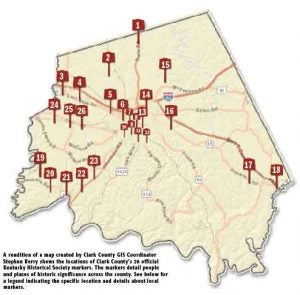
Clark County home to 26 official historical markers
1. Canewood
Located 6-1/2 miles north of Winchester on Kentucky 627.
Home of two Revolutionary War officers: built about 1793 by Col. Nathaniel Gist 1735-1796 and Gen. Charles Scott 1739-1813, Governor of Kentucky 1808-1812 who married the widow Gist, 1807.
2. Capt. Isaac Cunningham, 1778-1842
Located at 3375 Van Meter Road
Commanded a company of Kentucky Mounted Volunteer Militia from Clark and Bourbon counties during the War of 1812. Served in state legislature 1816 and 1827. Sheriff & Clark County magistrate. Visitors to his farm included Henry Clay, Daniel Webster, Gov. James Clark, and Hon. Richard Menifee.
Reverse: Grave of Capt. Isaac Cunningham. Isaac, and brother Robert, brought bluegrass seed from Virginia. They were among the first to cultivate bluegrass and use it as a crop in Ky. Also prominent in importing, breeding, and raising shorthorn cattle and thoroughbred horses. Isaac and his wife, Sarah Harness, are buried near this spot.
3. Clark County Hemp
Located 5 miles west of Winchester on US 60
One of the ten Bluegrass counties which produced over 90 percent of the entire country’s yield in late 1800s. Production increased from 155 tons in 1869 to over 1,000 tons in 1889, valued at about $125 per ton. In 1942, Winchester selected as site of one of 42 cordage plants built throughout country to offset fiber shortage during war. See over.
Reverse: Hemp in Kentucky – First crop grown, 1775. From 1840 to 1860, Ky.’s production largest in U.S. Peak in 1850 was 40,000 tons, with value of $5,000,000. Scores of factories made twine, rope, oakum to caulk sailing ships and cotton bagging. State’s largest cash crop until 1915. Market lost to imported jute, freed of tariff. As war measure, hemp grown again during World War II. See over.
4. East KY. Power Cooperative
Located 4758 Lexington Road
On July 7, 1941, thirteen of Kentucky’s rural electric co-ops formed East Kentucky Power Cooperative to relieve the electric power shortage common in rural areas. In 1951, Hugh L. Spurlock became EKPC’s first general manager. Construction began soon after on its first power plant, William C. Dale Station.
Reverse: East KY. Power Cooperative – Before 1937, only 3% of rural homes in Ky. had electricity. Today, electricity is available to all. EKPC supplies wholesale power to 18 electric co-ops that serve electricity needs of farms, homes, and businesses in eastern 2/3 of state. With headquarters here, EKPC operates three coal-fired generating plants in Somerset, Ford, and Maysville.
5. Capt. John Strode
Located 1 miles west of Winchester on US 60
Came from Va. to Boonesborough, 1776. Builder of Strode’s Station, 1779, the largest and most important fortified area in Clark County during the early settlements and bloody Indian wars. Indians attacked station 1781, and later. Two men killed first attack, none in later ones. Old burial ground unearthed, 1965, and the remains reinterred in Winchester Cemetery.
6. Allen Tate
Located 1107 W. Lexington Ave.
Born in Winchester, Allen Tate was a teacher and writer of prose and poetry of international fame. Also a leader of “New Criticism” poets and group known as Agrarians that supported the southern tradition. Helped found poetry magazine, “The Fugitive,” 1922-25, with Robert Penn Warren and others. He received the National Medal for Literature.
7. Hanson Home Site
Located on Lexington Avenue
Here lived five Hanson brothers, Civil War soldiers, USA and CSA. For USA: Col. Charles S., hero of Battle of Lebanon, July, 1863; Pvt. Samuel K.-died in service. For CSA: Brig. Gen. Roger, mortally wounded in the Battle of Stone’s River, Jan. 2, 1863; Pvt. Richard H. and Pvt. Isaac S. Sons of the Hon. Samuel and Matilda Hickman Hanson.
8. Gov. James Clark
Located at Colby Road
Home and monument of James Clark 1779-1839. Governor of Kentucky, 1836-1839. Member of Congress; Judge, Court of Appeals. As Circuit Judge he rendered his famous decision which set off the old and the new court fight in 1821.
9. County Named, 1793
Located on courthouse lawn
For General George Rogers Clark, who came to Kentucky territory from Virginia, 1775. He commanded expedition into Illinois territory in 1778-79, taking the British forts which held the northwest for future US settlement, and capturing commander of area. Originally taken from Bourbon and Fayette; covered area of 5 present counties and parts of 8 others.
10. Homer C. Ledford
Located at College Park
Homer Ledford (1927-2006) was a master craftsman, musician, and teacher. Born in Tennessee, he came to Kentucky to attend Berea College & graduated from Eastern Ky. University. Ledford founded the Cabin Creek Band in 1976 & led it for 30 years, entertained on four continents, and performed for five of Kentucky’s governors.
Reverse: Ledford crafted thousands of musical instruments. His banjos, violins, guitars, mandolins, and dulcimers are sought by musicians worldwide. The Smithsonian Institution houses three of his creations— a fretless banjo, an Appalachian dulcimer and a dulcitar, which he copyrighted. He played 13 musical instruments.
11. Courthouse Named
Located at courthouse
Clark County, named in honor of Revolutionary War hero General George Rogers Clark, was created in 1792. A two-room log cabin courthouse built here in 1794 on land donated by John Baker. Replaced by two-story brick bldg. in 1797. Third courthouse, built 1821, was where Henry Clay argued his last case before a jury, 1849.
Reverse: Today’s courthouse, designed by noted Lexington architect John McMurtry, was completed in 1855 at a cost of over $40,000. Clock tower raised and courtroom moved upstairs in 1889. Courthouse was expanded in 1938 by addition of a rear block matching the front. Listed on the National Register of Historic Places in 1974.
12. East Broadway Cemetery
Located East Broadway and Park Avenue
In 1833 town trustees bought about an acre for $45 for public burial ground. First cholera epidemic in U.S. reached here. Seventy-five victims were buried here in 1833. John Ward, town trustee and a leader in forming cemetery, and his wife were both plague victims. The cemetery used until 1854. Maintained as a memorial of that terrible tragedy.
13. “Morgan’s Men”
Located on courthouse lawn
CSA Gen. John H. Morgan’s cavalry first raided Kentucky July, 1862. Took Cynthiana but, faced by large USA forces, withdrew. Destroyed arms here on 19th and went to Richmond. On last raid, June 1864, after two battles at Mt. Sterling, they moved by here to Lexington and to Cynthiana where they met defeat on 12th and retreated to Virginia. See map on other side. Dedicated March 9, 1964.
14. Sculptor’s Birthplace
Located 1 mile east of Winchester on US 60
Birthplace of Joel Tanner Hart, 1810, sculptor and poet. Began as stone-cutter, 1830. Went to Florence, Italy, 1840. Famed for busts: John Jordan Crittenden, Cassius M. Clay, Henry Clay, Andrew Jackson. Marble statues: Woman Triumphant, Il Penseroso, Henry Clay, Angelina and others. Died, Italy, 1871. By Legislative Act, reburied Frankfort, 1887.
15. Colonel William Sudduth
Located on Wade’s Mill Road
Born in Virginia on November 25, 1765, he was an early settler of Clark Co. He served under Anthony Wayne in the campaign of 1794 & was Clark Co. surveyor for 30 yrs. A justice of the peace & sheriff, Col. Sudduth was last surviving member of the 1799 convention that framed Kentucky’s second constitution. He died in 1845.
16. Rare 1860 Tombstones
Located 3 miles south of Winchester on Kentucky 15
In the burial ground, one-fourth mile east, are two rare Carrara marble tombstones carved in Italy by Joel Tanner Hart, the world renowned sculptor. He brought the stones to America, 1860, at time of unveiling of his great statue of Henry Clay in Richmond, Va. Visiting his birthplace near here, he placed stones in memory of his parents, Josiah and Judith Hart.
17. Indian Old Fields
Located at 11 miles southeast of Winchester on Kentucky 15
Site of Eskippakithiki, sometimes called “Kentake,” located on the Warrior’s Path. This meeting place for traders and Indian hunters was the last of the Kentucky Indian towns. Occupied by the Shawnees, ca. 1715-1754. John Finley had a store here and traded with the Indians, 1752. Daniel Boone viewed “the beautiful level of Kentucky” from this point on June 7, 1769.
18. Lulbegrud Creek
Located at Clark-Powell Co. line on Kentucky 15
Near site of winter camp of Daniel and Squire Boone, Alexander Neeley, and John Stuart, 1769-70. Creek named by these pioneers after “Lorbrulgrud” of Gulliver’s Travels, first known book brought to Kentucky. Corrupted to Lulbegrud.
19. Caveland
Located at Jones Nursery Road, 7 miles north of Hootentown-Fayette Co. Line Road
Home of Richard Hickman. Born in Va., 1757. Built house in 1797. Clark County’s first legislative representative, 1793-98. Member 1799 Ky. Constitutional Convention. General in the Kentucky Militia. State senator, 1800-8, 1811-12, 1819-22. Lt. Gov., 1812-16, serving briefly as Governor in 1813 while Gov. Shelby led Ky. troops in War of 1812. Died in 1832. Buried here.
20. Boone-Callaway Girls Kidnapping
Located at 363 Athens-Boonesboro Road.
On July 14, 1776, Daniel Boone’s daughter, Jemima, and Richard Callaway’s daughters, Betsey and Fanny, left Fort Boonesborough to canoe on the Kentucky River. They drifted close to the bank near this spot and were captured by five Native Americans and taken north. Daniel Boone pursued them with eight men and rescued the girls unharmed two days later. Dedicated March 3, 2017.
21. Capt. John Holder
Located near Athens-Boonesboro Road and Howard’s Creek
An outstanding pioneer at Fort Boonesborough, 1776-81. Among the rescuers of Callaway and Boone girls captured by Indians. Named colonel of militia, 1779. Engaged in expeditions against Indians. In 1781 built Holder’s Station and operated boatyard at the mouth of Howard’s Creek. Led in the Battle of Upper Blue Licks, 1782. Trustee of Winchester, justice Co. Court.
22. Boone-Bush
Located at Quisenberry Lane and Boonesboro Road
Daniel Boone surveyed 6,147 acres for Captain Billy Bush. Bush located the land for himself and others, then served as pilot and marker on the surveys. Baptist families from Virginia and North Carolina began settling here in November 1784. The nucleus of the settlement was Providence Church on Lower Howard’s Creek.
23. Old Providence Church
Located 5 miles south of Winchester-Richmond Road at Old Stone Road
Daniel Boone attended; Squire, Jr., Samuel and Mary Boone baptized here. Church name changed, 1790, from Howard’s Creek to Providence. William Bush, a member of Boone’s second Kentucky expedition, built the present stone structure of native limestone. United Baptists formed here in 1801. Building was passed to Negro Baptists, 1870. Restored after slight fire damage, 1949.
24. Spring Hill
Located 6-1/2 miles west of Winchester on Colby Road
Home of Hubbard Taylor, soldier, surveyor, politician. Born, Va., 1760; in Am. Revolution, 1776-78. Came to Ky. as surveyor, 1780. In 1790 brought family, built this home. In first Ky. Const. Conv., 1792; in Ky. Senate, 1796-1800 and 1815-19. Presidential elector six times. Died in 1840. His kinsman, Pres. James Madison, visited here; also Henry Clay, other statesmen.
25. Roy Stuart Cluke
Located 6 miles of Winchester on Kentucky 1927
Site of home and farm from which Cluke enlisted in the Confederate army. Commissioned Colonel of 8th Regt. Ky. Cavalry CSA, Sept. 1862. Immediate action in Ky. won the confidence of Gen. John H. Morgan; was with Morgan in Dec. 1862 and July 1863 raids when captured in Ohio. He died December 31, 1863, in U.S. prison, age 39. Buried near Morgan in Lexington Cemetery. Erected October 7, 1964.
26. Colbyville Tavern
Located 5 miles west of Winchester at Colby Road and Becknerville Road
Built in 1820s by Colby Taylor as a place of rest and entertainment on stage road from Winchester to Lexington. In 1832, President Andrew Jackson visited here on his trip to Winchester. During antebellum heyday in late 1840s, popular stop for those on way to Olympian Springs in Bath Co. These grounds were used as muster-and-drill area for the Winchester Light Infantry.
About Whitney Leggett
Whitney Leggett is managing editor of The Winchester Sun and Winchester Living magazine. To contact her, email whitney.leggett@winchestersun.com or call 859-759-0049.
 More by Whitney